In Barcelona, the temperatures are getting hotter and the hottest periods are becoming more frequent, while rainfall is becoming increasingly irregular and less frequent.
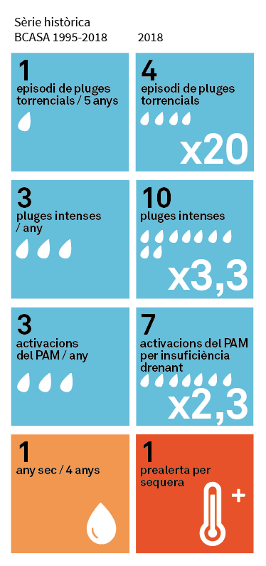
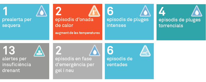
2018 is highly representative of the climate risks Barcelona is starting to face, with notable events including a drought pre-alert, a clear rise in temperatures, two heat wave episodes, six episodes of heavy rainfall, four torrential downpours and thirteen insufficient drainage alerts, two emergency-phase episodes for ice and snow, and six episodes of gales.
Increasingly high temperatures
Temperatures in Barcelona city have been increasing since 2016. Heat waves have been occurring intermittently in recent years, particularly since 2003, which was the year with the most heat waves, with a total of thirteen. Since 2012 in Barcelona city, there have been nineteen heat waves, ten of which have been in the last two years, in 2017 and 2018.
It rains less and less
Average rainfall is decreasing. Although average accumulated rainfall has been going down in recent years, it varies greatly from year to year which makes it difficult to establish a periodicity for the data observed.
2018 was an exceptionally rainy year (with the fifth highest accumulated rainfall, 923 mm, since 1914) and with episodes of intense rainfall (some of which were exceptional) following three years of rainfall below the average for Barcelona (587 mm), which led to a drought alert and pre-alert in January 2018. 2015 was an extremely dry year (just 321 mm of accumulated rainfall) and yet there were three episodes of intense rainfall.